


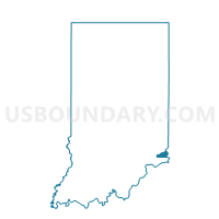
RANDOLPH 2, Ohio County, Indiana
About
Outline

Summary
| Unique Area Identifier | 579949 |
| Name | RANDOLPH 2 |
| County | Ohio County |
| State | Indiana |
| Area (square miles) | 0.39 |
| Land Area (square miles) | 0.39 |
| Water Area (square miles) | 0.00 |
| % of Land Area | 100.00 |
| % of Water Area | 0.00 |
| Latitude of the Internal Point | 38.94914740 |
| Longtitude of the Internal Point | -84.86317250 |
Maps


Graphs
Select a template below for downloading or customizing gragh for RANDOLPH 2, Ohio County, Indiana


Neighbors
Neighoring Voting District (by Name) Neighboring Voting District on the Map
- RANDOLPH 1, Ohio County, IN
- RANDOLPH 10, Ohio County, IN
- RANDOLPH 11, Ohio County, IN
- RANDOLPH 3, Ohio County, IN
- RANDOLPH 4, Ohio County, IN
- RANDOLPH 5, Ohio County, IN
- RANDOLPH 6, Ohio County, IN